


|
Gozo (In Maltese Ghawdex) is linked to Malta either by a ferry, or by a helicopter service. |
|
|
|
Gozo has a character quite distinct from that of Malta. The countryside is greener and more spectacular. Flat-topped hills characterize the landscape whilst the coast has rugged cliffs, penetrated by steep valleys and beautiful bays. |

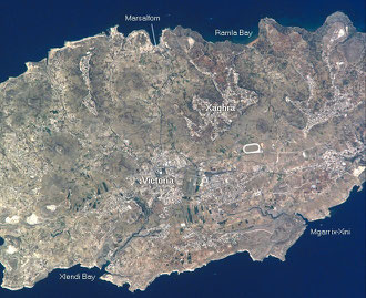
Gozo's landscape is rural with deep valleys and hilltop villages, with a rugged coastline ready to be explored. There are sand and smooth rocky beaches for relaxation, and clear safe waters for swimming.
Gozo Coat Of Arms


The Ferry schedule is very frequent with trips every hour during day time, with a few changes during the off season.
Current Gozo Ferry schedule:
| Winter Schedule From 3-Nov-08 to 24-May-09 |
||||||||||||||||||||||||||||||||||||||||||||||||||||
|
ZEBBUG
Zebbug is perched on a hill to the north of Gozo. It takes its name from the Maltese word for “olives”.
The village is actually built on two adjoining hills, from where the most panoramic views of the Gozitan countryside and the Mediterranean can be enjoyed. On a slope facing Gordan Lighthouse, there was a deposit of onyx. It was discovered by the owner of the field in 1738 and many churches in Malta and Gozo have works of art sculpted out of this onyx.
The village church of Zebbug is dedicated to Santa Marija and is literally covered with this semi-precious stone, most notable are the high altar, the choir and baptistery. Worthy of special mention is the altar-piece of the Immaculate conception in the chapel in the left transept known by the people as tal-Virtu, “of virtues”. Several folk swear to this day, that they see the radiant face of the Virgin turning yellow and pale before an impending natural catastrophe. It is also said that when some corsairs dared to devastate the countryside, advancing as far as the village, a lady resembling the image of the altarpiece appeared on the spot hurling stones to repel the foe.
The people of Zebbug are known for the high quality of their lace, weaving and woollen blankets. The villagers are very proud of their religious heritage, as can be judged from the priority given to the maintenance of street niches. The best is that of Our Mother of Mercy, better known as tac-Cicri
MARSALFORN
Marsalforn is the most popular summer resort of Gozo. The name is a composite word, meaning the “harbour of caves hollowed by the sea”. Up to the seventeenth century, before the development of MgarrHarbour, Marsalforn was the principal seaport of Gozo. The seaside resort is well served with hotels, apartments, restaurants, bars, as well as diving and water sports clubs. It comes to life during the warm summer evenings. Then a festive atmosphere prevails with people relaxing over al fresco meals, and meting friends on the promenade for walks and talks.
The church of Marsalforn, dedicated to St. Paul Shipwreck is recorded very early. The present building dates to 1730. Tradition holds that St. Paul, after his three month stay in Malta left the island from the tiny port just beneath the church. Marsalforn is the closest port to Sicily from the Maltese islands.
A scenic promenade leads from Marsalforn to Qbajjar and Xwejni where a number of saltpans dating from Roman times are still in use. A redoubt dating back to 1620 still stands on the shoreline
Gharb meaning “west” is the westernmost village in Gozo. On the road from Victoria to Gharb there is an aqueduct built by the British in the early 18940s to carry water from Ghar Ilma to Rabat. Further on in the same direction, one can still see an old fortified country house raised in the 1600s and parallel to this on the other side of the road, there is an old windmill known as tal-Qasam, “of the agricultural estate”.
Just before you approach the village a road forks right to the Shrine of Blessed Virgin of
Ta'Pinu.
The monumental shrine was built between 1920 and 1931./ worth a climb is Ta’ Ghammar Hill right in front of Ta' Pinu Shrine. A Via crucis or Way of the cross made up of fourteen marble
statuary groups line the way to the top. There are two small museums related to the Shrine. The first houses the Karmni Grima Museum, home of young country woman who received a message
for prayer from the Virgin Mary in the venerated tiny chapel attached to the Shrine. In the village square of Gharb one can also find another folklore museum.
The parish church of Gharb is one of the most architecturally perfect churches of Gozo and is designed on Francesco Borromini’s Sant’Agnese in Agone at Piazza Novana in Rome. It was dedicated in 1729 to the Visitation of the Virgin Mary to Elizabeth and beautiful sculptures are to be found both on the exterior and interior.
Gharb is a place of intense natural beauty, especially in the area around the ancient chapel of the bishop-martyr San Dimitri. The story goes that after an old woman beseeched the saint to saves her only son from slavery, San Dimitri left the altar-piece on his flying stallion and soon brought back her son Mattew. The altarpiece can still be seen in the chapel.
Ghasri’'s village church was built early in the twentieth century and is dedicated to christ the Saviour. Other chapels in Ghasri are St. Publius chapel an on the road to Wied il-Ghasri, the rural chapel dedicated to the Patronage of Our Lady.
From the village square, a road leads to Wied il-Ghasri, at the mouth of which there is a quiet tiny beach wedged between the cliffs. The coast from Wied il-Ghasri goes on to Marsalfo
SAN LAWRENZ
San Lawrenz takes its name from an old chapel that stood in the area from at least 1575.
On the Rabat-Gharb-San Lawrenz road at the village approach one can find the Gozo crafts Village. It lies below Ta' Dbiegi, the highest hill of Gozo. The village church, dedicated to Saint Lawrence, was built between 1888 and 1897, on the site of the old chapel
From the village square one takes the road down to Dwejra Bay where there is a chapel dedicated to St. Anne. Also in Dwejra is a well preserved watch tower dating back to 1652, built to guard the then famous medicinal plant which grew on Fungus Rock. This is one of the towers that the Knights of St. John erected during the 17th century. Most of these towers survive.
Dwejra boasts of several natural wonders foremost “Il-Gebla tal-General” referred to as “Fungus Rock”, the “Azure Window” and “Il-Qawra” the “Inland Sea”. Such is the impact of this beautiful area, that it is frequently used as a filming location for the movie industry
Santa Lucija
Santa Lucija is a suburb of Kercem and takes its name from an old chapel dedicated to Saint Lucy, recorded as early as 1575. the present parish church, dedicated to the same Saint, is invoked by those who have problems with their eyesight.
The Rabat – Santa Lucja road leads to the village square with a typical stone cross in its centre. From the square a street on the right leads towards Ghajn Abdul plateau and by forming right after two hundred metres, up to il-Mixta, the site of the earliest settlement in Gozo
The street on the left of the church proceeds to l-Ghadira ta'San Rafflu and from there, a path in the fields parallel to the cliffs leads to Ras il-Wardija, the site of a Punic settlement that included a small temple. There are still some remains
VICTORIA
Victoria is known to one and all as Rabat, meaning suburb, as this city developed as the suburb of the citadel. The name of Victoria was given to the town in 1887, in honour of Queen Victoria in her jubilee year.
Victoria is the capital of Gozo, which lies precisely in the centre of the island and is the most populated town. It is the administrative centre, which includes also the main schools, the hospital, and the law courts, serving the island’s community. Its main square is Pjazza Indipendenza, popularly known as it-Tokk. The main building on the square is the Banca Giuratale, built between1733-38, formerly the seat of the municipal government of Gozo and presently of the Victoria Local council. An open market is held every morning in this square and several open air cafes are also found here
Republic Street is Victoria’s main street, flanked by shops, banks, theatres, restaurants, Police Headquarters, the Bishop’s chancery and il-Mall or Rundle Gardens. These gardens were laid out by the British in 1910 and house a variety of local and imported trees, an oasis of peace in the centre of the busy town. Just off the main square in the very heart of the old town, one finds the medieval parish church of St. George Martyr, referred to as the marble basilica, as it is entirely covered in marble. The present basilica was rebuilt by its supporters after the destruction by an earthquake in 1693. It has a profusely gilded interior and very impressive is the bronze and gilded canopy over the high altar. The main attraction is a statue of the patron Saint, St. George, sculpted in wood in 1838.
An interesting chapel, among the many that are found in Victoria, is the 19th century chapel dedicated to Saint Martha, built in 1859. During winter months, Victoria bustles with activity from sun rise to sun set. Shoppers and friends mill around its main streets and quaint side roads, greeting each other, stopping to chat and catch up with the local gossip. In summer, however it quietens down as most people seek sea breezes in the popular summer resorts.
A visit to the citadel is a must and the fatigue of going up the hill is fully rewarded. From the fortifications there is a superb view all around the horizon with vistas over the tiny fields cut by yellow stone walls, domes of village churches rising from clusters of houses and the Gordan Lighthouse.
The number of inhabitants in the citadel is less than ten and half the place lie in archaeological ruins which are continuously being restored. This results from an exodus in the 17th century to more spacious houses in Victoria. In the other half there is the Gozo cathedral and the Law courts, as well as the cathedral Museum, the Gozo Museum of Archaeology, the Folklore Museum, the Natural History Museum and the Old Prisons.
The most impressive of all is the cathedral, dedicated to Santa Marija, the Assumption. A centuries-old belief, partly proved archaeologically, noted that a temple to Juno that had existed within the acropolis was rededicated by the early christians to the Blessed Virgin Mary. When the present building was raised between 1697 and 1711, remains of this temple were discovered in abundance.
The cathedral is a fine baroque structure in the form of a Latin cross and is built entirely of the local limestone on a plan by the Maltese architect Lorenzo Gafa’. Instead of bell towers, a tall campanile with five bells is attached to the north east side. The interior is very graceful and well-proportioned. A flat ceiling in perspective closes the aperture of the dome. This ingenious painting, raised in place in 1739, is one of the cathedral’s major attractions and is so convincing that many visitors have to be persuaded that it is not, indeed, a real dome. The other attraction is the statue of Santa Marija, the Assumption, undertaken in Rome in 1897. The statue of the Madonna was embellished with a diamond necklace, a gold belt and a solid silver plinth donated by Gozitans who emigrated to the New World and made good. On 15th August, it is taken shoulder-high in a procession around the streets of Victoria.
NADUR
Nadur is spread over the top of a tale-flat hill. It’s name is most appropriate as it means to “keep guard”.
Overlooking the little bay of Dahlet Qorrot, Ta'Sopu Tower was built for this purpose in 1667, however in 1798 French troops still managed to make a landing in Gozo at an area known as Ta'Venuta, a location close to Ta'Sopu Tower, but unfortunately out of its range.
The restored Ta'Kenuna Tower, is used for artistic exhibitions and was built in 1848 by the British to serve as a telegraph link between Gozo and Malta.
On the Rabat – Nadur road, one finds the Gozo horse-racing track and the Gozo scrambling track. The best way to Ramla Bay is by this road. Beyond the village school the road leads to fertile Wied San Blas and Dahlet Qorrot Bay.
On the Nadur – Qala road an area known as il-Buskett, once a very wooded area, was the venue of the traditional feast of l-Imnarja, the feast of St. Peter and St. Paul, to whom the parish is dedicated. On the eve of the 29the of June, people used to gather in the area to spend the night barbecuing rabbits and singing to the accompaniment of guitars.
The monumental church of the Saints Peter and Paul was begun in 1760, however the façade and aisles were built at the beginning of the 20th century. The church is entirely covered in marble and has also a pulpit sculpted in marble.
The Gozo Maritime Museum is just off the village square
QALA
Qala is the easternmost village of Gozo and it’s name means “sheltered harbour”.
The Rabat – Qala road, just before a lane on the left leading to the village of Ghajnsielem, passes over a Neolithic settlement known as Tal-Qighan an l-Imrejzbiet. There are several megaliths of considerable sizes still in place.
Also of interest at Ras il-Qala, there is a defensive battery constructed by the Knights of St. John.
In Qala, in Triq il-Wileg, there is a windmill with sails and equipment and another windmill close by is found in Triq TacGrunju. The main street passes through the village square and on towards the bays of iz-Zriezaq and Hondoq ir-Rummien.
On the way to these two bays one finds the Sanctuary of the Immaculate conception of the Blessed Virgin Mary. The church houses one of the best paintings in Gozo, an oil on canvas of the conception by Federico Barocci di Urbino. People use to flock to the chapel seeking divine intercession and the walls of the chapel were once covered with ex-voto paintings donated by those who were healed. This chapel is one of the oldest in Gozo. The parish church of Qala is dedicated to St. Joseph and was built between 1882 and 1889, in the baroque style, a style much favoured in the 17th and the latter half of the 20th. century
GHAJNSIELEM
Ghajnsielem just off Mgarr harbour simply means “Salem’s Spring” the monument in the square in the very centre of the village honours Anglu Grech, a farmer who lived in the vicinity and who, according to tradition, had a vision from the Blessed Virgin Mary requesting him to build a church, which was duly built in 1820 and dedicated to Our Lady Loreto. clearly visible from the Gozo ferry as it enters the port, is the church of Our Lady of Lourdes perched above Mgarr harbour. From the parvis there are excellent views of the channel.
In 1749 to make the harbour and the channel safer, the Knights commenced the construction of citta Vilhena, which however became known as Fort chambray, after Jacques Francois chambray, Lieutenant General of the Ships and Governor of Gozo, who bequeathed most of his property for its building. Its impressive gunpowder magazine and the watch-tower as well as most of the fortifications stand to this day
On the corner of the Ghajnsielem – Victoria road, just in front of the road leading to the Heliport, there is Santa Cecilja tower, built in the 17th century to ease communications between coastal towers. Next to it there is the derelict chapel of Saint cecilia, the oldest chapel in Gozo. Also on this road one comes across the Gozo Heritage, a historical re-creation of the momentous episodes of seven thousand years on Gozo life, from prehistory down to recent times.
SANNAT
Sannat lies to the south of the island and its name is probably another Arabic family name.
The Rabat-Sannat road proceeds past the church to Tac-Cenc, an expanse of prime interest. Besides the excellent views of the countryside and the sea, there is a great variety of wild plants for the nature lover an several prehistoric remains. The most prominent is L-Imramma Temple, a primitive type of temple made up of a sort of oval court with a series of more or less oval rooms to the north. Other interesting remains are three dolmens.
The small bay of Mgarr Ix-Xini is at the end of the plateau. It is guarded by a tower which alerted the citadel by firing mortars or lighting a bonfire. The dejma or local militia would then rush to the spot to hinder a landing. Today pleasure boats in the bay encounter no such problems.
The village church of Sannatis dedicated to St. Margaret Martyr and was begun in 1718, and has an excellent altarpiece by the famed local artist Stefano Errardi.
MUNXAR
Munxar, a suburb of Sannat, lies on the very southern tip of Rabat and its name is the Maltese name for “bucksaw”. The church of Munxar is dedicated to St. Paul Shipwreck, the same as that of Marsalforn. Beyond the church, a road leads to Ras il-Bajjada and then to Xlendi. The area offers the visitor breathtaking views over the open sea and is ideal for relaxing walks.
XLENDI
Xlendi is a typical fishing village and a popular summer resort. It takes its name from a type of Byzantine vessel that used to shelter in this port.
Wedged between majestic cliffs, Xlendi is the most picturesque and the most romantic fishing village of Gozo. Before the present high rise buildings, constructed since the 1960’s, a white statue of the apostle Saint Andrew, patron saint of fishermen, reigned over the port. It still dominates the little harbour where fishing boats create a colourful collection when they are moored.
The cliffs bordering the inlet on this side can be reached by walking past the statue to a steep flight of steps cut into the rock. From the top there is a bird’s eye view of Xlendi. Further down the path, there is L-Ghar ta' Karolina, “caroline’s cave”, a natural grotto one used by nuns for swimming.
Xlendi tower, on the opposite promontory, was raised in 1650. it is a massive building that was able to resist gunpowder shots. Its stairway was detached from the main structure and the moat was spanned by an elevating drawbridge. Xlendi church is dedicated to the Virgin Mary of Mount carmel and the front section dates in 1868.
Xlendi is a main summer resort. Restaurant line the seafront, keeping the little bay busy from morning till late evenings entertaining their patrons to al fresco meals. Diving centres, hotels and a couple of clubs may also be found in Xlendi.
XAGHRA
Xaghra rises on a hill in the central northeast of Gozo. Its name refers to the wilderness of the hill before it was inhabited.
On the village approach, from the Rabat-Xaghra road one finds the GgantijaTemples and about half a kilometre to the north of the temples, there is the Stone circle, an underground cemetery of the temple builders. The site was first excavated in the early 1990s, but it has since been covered. Further up at the end of Santa Verna Street there is a group of three upright megaliths in the middle of the fields. Three horizontal blocks lining the east side of the uprights are similar to the high bench on the facades of some of the major temples, suggesting that another temple might have stood on the site.
Just off the Ggantija Temples one can visit Ta' Kola Windmill. Built in 1725 and named after an early miller, this windmill is still in working condition. During the Axis blockade of the Second World War, the mill was put to good use saving many from starvation.
Just off the village square one can also visit two small stalagmitic caves, Ghar Ninu and Ghar Xerri. On the Xaghra – Marsalforn road that starts on the left of the church, the side road to the right, leads to the legendary cave of calypso, where legend has it that Ulysses bewitched by the nymph spent seven idle years. Once inside the cave the views of Ramla l-Hamra bay and the valley are indeed breathtaking.
The parish of church of Xaghra is dedicated to the Nativity of the Virgin Mary, locally known as Il-Vitorja, “The Victory”, so called because it celebrates the victory of the Knights over Islam. The main attraction of the church is a beautiful statue of the young Virgin Mary, brought from Marseilles in 1878.
In January, a ceremony of the blessing of animals is held in the little square of the chapel of Saint Anthony the Abbot. This is an old tradition dating back to the Knights of St. John.
XEWKIJA
Xewkija the village of the rotunda church, takes its name from a place where thistles grew.
At the crossroads (and traffic lights) on the Rabat-Xewkija-Mgarr road, there is a unique windmill. Instead of a square building, it is an eight-sided edifice corresponding to the eight points of the compass and the eight dominant winds.
A most spectacular effort is the parish church dome dedicated to St. John The Baptist. completed in 1981 and paid for by the 3,500 villagers, it boasts the third largest supported dome in the world, coming in after St. Peter’s in Rome. The dome is 74 metres high, with a diameter of 27 metres and a circumference of 85 metres. Its total weight is calculated to be around 45,000 tonnes.
Of particular interest is the chapel of Our Lady of Mercy around which revolves a legend about a thief who wanted to steal a golden chalice, but ended up joining a hermit to repay his sins.
Wied Hanzira, literally meaning the “valley of the sow” is one of the deepest valleys on the island and a veritable haven for the lover of wild plants. It flows southwards from the end of the village
Xewkija is an active village. It comprises Gozo’s industrial zone, where factories produce a number of articles for local use and for export. During weekends, the road that from Xewkija leads to Rabat, is thronged by football fans intent on an afternoon’s entertainment at the adjacent football stadium
As the Gozo ferry approaches Mgarr Harbour and its gangway is lowered, one is immediately enthralled by the breathtaking charm of Gozo’s link to the outside world.
On one side Fort chambray, built by the Knights of St. John in 1749, majestically and defiantly guards the harbour from its vantage point, while the church dedicated to Our Lady of Lourdes is a prominent landmark overlooking the harbour. To the right, the terraced fields slope gently down to the sea.
To this day, Mgarr harbour is still the most important fishing base and provides the best winter shelter for the island’s fishing boats, while the adjacent marina hosts pleasure sea craft throughout he year.
Beyond the harbour the other towns, villages and attractions of Gozo are just silently waiting to be discovered